


Professor’s New Book Captures the Country’s History in 100 Maps
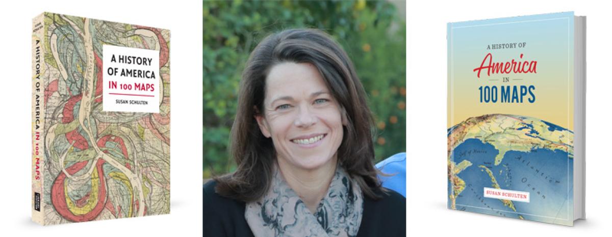
As University of Denver history professor Susan Schulten sees it, a good map — whether centuries old or made yesterday, whether produced by a professional cartographer or a 19th century schoolgirl — can take the armchair explorer in surprising directions.
That premise animates her latest book, “A History of America in 100 Maps,” already in U.S. bookstores and scheduled to debut at their British counterparts in November. Co-published by the University of Chicago Press and the British Library Press, the book spans the centuries between 1492 and the digital age. But even with its sequential presentation of material, it’s not so much a survey of history as an examination of how maps record the past.
“The point of the book,” Schulten explains, “is not to cover American history but to showcase what maps can do for history, the way they can unearth new dynamics and narratives and power relationships.”
Schulten is known to history fans, “map maniacs” and her peers in higher education for her groundbreaking 2012 book, “Mapping the Nation: History and Cartography in Nineteenth Century America,” also published by the University of Chicago Press. With its companion website, that book chronicles how Americans made inventive use of maps to trace epidemics, better understand weather patterns and share complex information related to everything from the growth of slavery to the expansion of territory.
The popularity of “Mapping the Nation,” which still sells briskly, paved the way for another map-rich research opportunity. A couple of years ago, Schulten recalls, she fielded an out-of-the-blue call from the British Library. “They said, ‘Would you be interested in a book that narrates American history through material from our library? What about the history of America in 100 maps?’”
Schulten didn’t hesitate. The chance to work with a world-famous stash of treasures was too tantalizing to resist. “The British Library has one of the largest map collections in the world — and one of the strongest collections of American material, which makes perfect sense if you think about it, America being a former British colony,” she says.
Initially, the library proposed that the book focus on all of North America, but Schulten hesitated. “I was pretty clear with them that there were limits to my expertise. It was enough of a stretch for me to go back to the 15th century. That was a new challenge for me.”
The library offered Schulten free range through its collection, but because, as she explains, “their strength is really prior to the American revolution,” she supplemented the library’s holdings with maps from selections from this side of the pond. Aided by a Public Scholar Fellowship from the National Endowment for the Humanities, Schulten then set to work writing the narratives that accompany each map.
Some of the maps have long been recognized as important, such as those depictions of the world that prompted the European voyages of discovery, or those used by the French and British in their struggle to control North America across the 18th century.
“Next to those, I also wanted really unexpected maps,” Schulten says, “ones that challenged our assumptions about what a map is, and why it might matter.”
Among the unexpected offerings are:
• A 1721 map painted on deerskin by Native Americans in the Southeast seeking to negotiate with South Carolina. As the book notes, the deerskin creation looks less like a map than an organizational chart, but it portrays the region’s different tribes according to their power and serves as a guide to trade relationships among Native Americans and Europeans. “It’s essentially about a welter of interests,” Schulten says. “All these different tribes are vying for a place in the deerskin trade.”
• An 1818 map of the country, rendered by the schoolgirl Catharine M. Cook, that offers insight into the schooling of American females. “Right after the revolution, Americans began to educate girls outside the home; they put them in school with other young girls. One of the first things they taught them to do was draw maps. … Considered together, these maps reveal the experience of the first generation of girls to be educated in the new nation.” With its misspellings, artistic flourishes and careful attempts at scale, Cook’s map hints at just what society expected of young women. “Notice that she’s being taught not just geography,” Schulten says, “but penmanship, calligraphy, watercolor and self-discipline.”
• A World War II map depicting the U.S. Army’s XIX Corps in action, from D Day to the defeat of the Germans nearly a year later. Made by a young engineer, the map doubles as a journal and travelogue. “What he has done is to draw for his company and his fellow soldiers a memoir through a map of where they went,” Schulten says, noting that for millions of American soldiers, the trek through Europe represented their first trip outside their own country. “This map is his memoir of those places, as well as a record of the fighting. It’s a way of understanding the logic of the march.”
• Four maps of North Carolina’s 12th congressional district. The book’s only new maps were commissioned by Schulten to demonstrate gerrymandering in the digital age. Created by Kelly Measom, a DU graduate student in geography, the maps show the shifting borders of the district, in the news because of a recent Supreme Court decision reviewing the constitutionality of the state’s gerrymandering efforts. “It’s understood to be one of the craziest districts, barely contiguous,” Schulten says, adding that Measom’s maps show dramatic changes in district boundaries from 1993 to 2018.
Other maps cover imaginary terrain. One 19th century map by a temperance activist plots the diverging routes to inebriation and sobriety. Still another map — made for the 1939 World’s Fair — skewers the provincialism of New Yorkers by mapping the country as imagined from Manhattan, with South Dakota tucked inside its northern sibling and with Yellowstone sited in Colorado. “Though fictional,” Schulten says, “these maps convey larger truths, in this case the urgency of temperance in the 1830s or the larger human tendency to see geography in self-referential terms.”
For Schulten, historical maps represent more than pretty pictures. Regardless of their subject matter, she says, “Maps offer a pretty rich way to get into the past.”
See the past through maps at www.america100maps.com.